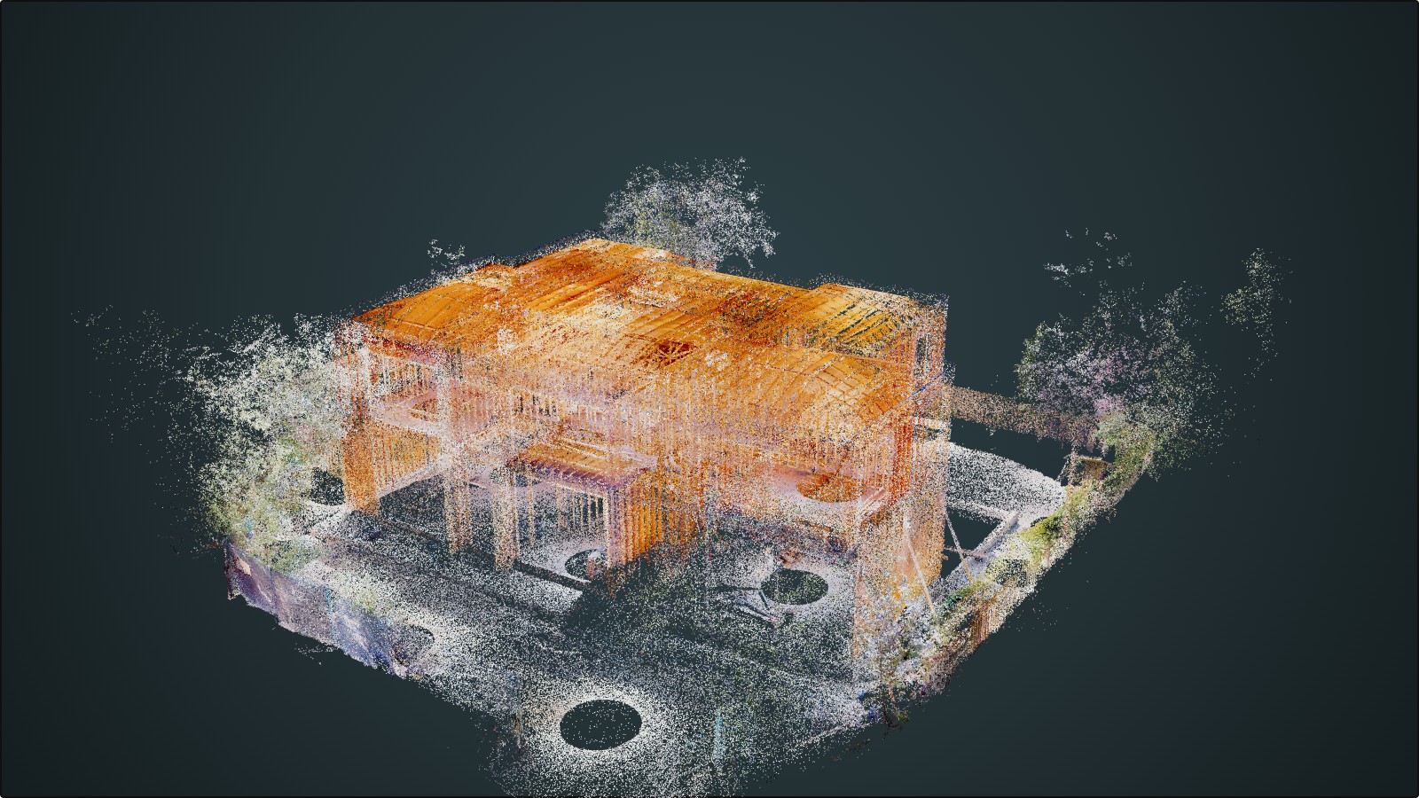
A foundation is only fully visible for a few weeks. Here is what disappears at backfill, what a 3D record of the open excavation keeps, and how one in Forest Hill South was captured and handed over.
A foundation is only fully visible for a few weeks. The walls are poured, the waterproofing and drainage are on, the shoring is still holding the excavation open, and then the backfill goes in. From that day on, everything below grade is known only from the drawings, the site photos and whoever remembers.
This post is about that short window: what disappears when it closes, and what a 3D record of the open excavation keeps. The worked example is a new house foundation we captured in Forest Hill South, Toronto, in October 2026.
What disappears at backfill
Once the excavation is filled, a set of facts becomes expensive to check:
- Where the walls actually are, as opposed to where the drawings put them
- Openings and sleeves, the penetrations that services will later need to find
- Waterproofing and drainage, including membrane laps, the drainage layer and drain outlets, which matter most when something leaks years later
- Temporary works, like the steel rakers and struts that braced the dig, which leave no trace at all once they are removed
None of this is hidden on purpose. It is simply buried. After backfill, every question about a drain run, a sleeve or a wall position goes back to the drawings, or to an excavator.
The natural window
There is already a moment in the schedule when the foundation is finished and still open. Ontario's building code asks for an inspection notice once footings and foundations are complete and before backfill. That is the window we book the capture for: the work is done, nothing is covered yet, and the site is about to change for good.
What we captured in Forest Hill South
When we arrived, the concrete walls were poured, the steel rakers were still bracing them, and nothing had been backfilled.
We used two captures, because neither sees everything on its own:
- Terrestrial laser scanning from 24 stations around and inside the excavation. This is the geometry: the measured shape of the walls, the floor and the shoring.
- Two drone flights, one looking straight down and one at an oblique angle. These supply the colour, and the views into the pit that a tripod at grade cannot reach.
The two were fused into a single georeferenced textured model of 12.3 million faces. From that we built the 3D foundation model, and a web version of both, sized to open on an ordinary laptop or phone. The web build of the textured model is 1.68 million triangles.
What the owner and builder get
The working files stay the working files. What changes is that everyone on the project can see the foundation without a site visit or a desktop licence.
The main deliverable is a private viewer link. It opens in any browser, phone and iPad included, and shows:
- The textured model, the point cloud and the 3D model, each on its own tab, all sharing one camera, so switching keeps you looking at the same wall
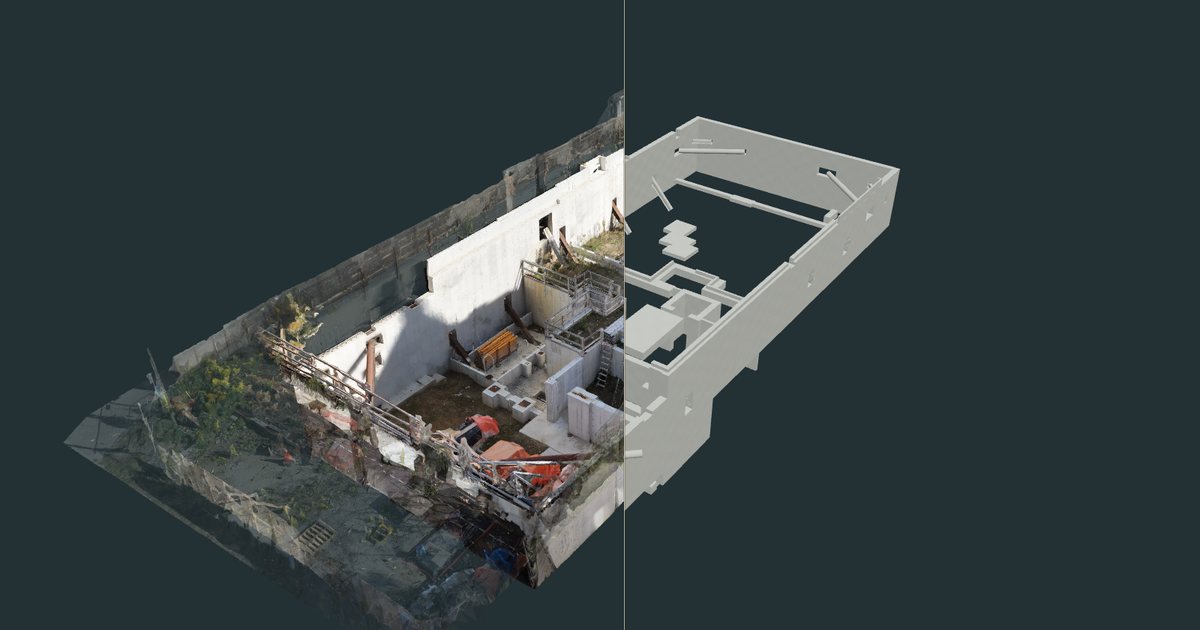
- A side-by-side comparison of the captured site and the 3D model, with a divider you drag across the excavation
- Numbered notes on the items worth finding again, such as the shoring, a wall, the lowest level and a steel column. The client can add, edit and remove notes themselves, so the record grows with what they learn
- Section cuts, to look down into the dig or see a wall in section
- Links that reopen an exact view, and saved images for reports and emails
- An approximate measure, for orientation and quick checks
Behind the link sit the files that carry the measurement record: the registered point cloud in E57, the full-resolution textured model and the 3D foundation model. As a fixed-scope package, a dated record sheet with plan, elevation and close-up views comes with them.
Where the record pays off later
The capture is made for the current build, but most of its value comes years later:
- A renovation, a pool or a new service connection. The record shows where the walls, sleeves and drains are before anyone digs.
- A dated baseline. If a defect, a neighbour complaint or an insurance claim ever turns on what was built, there is a 3D record of the foundation as it stood before backfill.
- The house file. When the property changes hands, the foundation goes with it as something a buyer's engineer can actually look at.
What a web view is, and what it isn't
The browser view is for seeing and sharing. The comparison you can open on the project page lines the scan up with the model by eye, so it is a visual comparison, not a measurement. Dimensions come from the registered point cloud. Where a check has to be binding, the call stays with the project's engineer or surveyor; the record gives them the data to make it.
See it yourself
The Forest Hill South comparison is on the project page: drag the divider across the excavation and turn the view.
Explore the Forest Hill South foundation →
The same capture is available as a fixed-scope package, booked into the days before backfill: the Pre-Backfill Foundation Record.
Have a foundation going in? Tell us when the backfill is booked, and we will come back with a capture date.